Part 4 · Comfort, Lighting & Your Truck
Weather
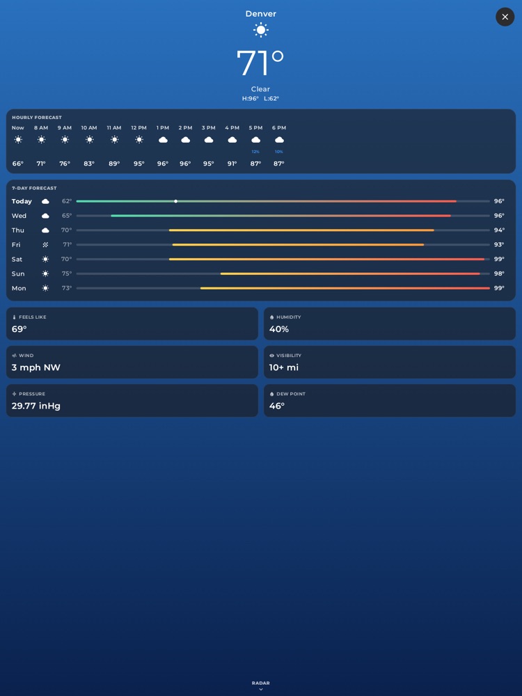
The Weather view: current conditions, hourly and 7-day forecast, and detail cards.
A full-screen weather view with current conditions, an hourly forecast, a 7-day outlook, detailed readings, and a live animated precipitation radar you can scrub and play. The whole page is tinted by a beautiful sky gradient that matches the real weather and time of day, so a glance tells you the story before you read a single number.
Where to find it: Tap the outside temperature shown in the top-left of the header (the number with the little degree mark, next to the lock icon and clock). That temperature is your live shortcut into the full Weather view.
When you'll use it: Checking whether to expect rain on the drive, seeing how cold it'll get overnight before a camp, watching a storm cell move across the radar, or just glancing at the feels-like temperature before you head out.
The screen, part by part
The Weather view is two full-screen pages stacked vertically. You start on the Forecast page, and you swipe up to reach the Radar page. A small "RADAR" label with a down-chevron sits at the bottom center of the forecast page to remind you it's there.
At the very top-right of the whole view is a round X (close) button — tap it to return to wherever you were.
Forecast page — the hero (top)
- Place name — the city or area you're currently in, found automatically from your location. If it can't be named, it reads "Current Location."
- Weather icon — a big glyph for the current sky (sun, moon, clouds, rain umbrella, snowflake, fog, or thunderstorm). It switches to a moon at night.
- Large temperature — the current outdoor temperature in whole degrees Fahrenheit, shown big and thin so it's readable at a glance.
- Condition text — a plain description like "Clear," "Partly Cloudy," "Light Rain," or "Thunderstorm."
- High / Low — today's forecast high and low ("H:88° L:64°").
Forecast page — Hourly forecast card
A horizontal strip you swipe left/right through. It covers roughly the next 12 hours. Each column shows:
- The hour (the first one is labeled "Now").
- A small weather icon for that hour.
- A blue precipitation percentage — this only appears when there's a real chance (10% or more), so an empty spot means rain is unlikely.
- The temperature for that hour.
Forecast page — 7-Day forecast card
One row per day for the week ahead. Each row shows:
- The weekday (the first is "Today" and is bold).
- A weather icon for the day.
- The low (dimmed, on the left) and the high (bright, on the right).
- A colored range bar between them. The bar is tinted by temperature — cool blues for cold, warm oranges and reds for hot — and its length shows where that day's high-to-low range sits within the whole week's spread. On today's row, a small white dot marks exactly where the current temperature falls along that range.
Forecast page — Details grid
Six tiles, each with a small icon, a label, and a value:
- Feels Like — the apparent temperature (accounts for wind and humidity).
- Humidity — relative humidity as a percentage.
- Wind — speed in mph plus a compass direction (like "12 mph NW").
- Visibility — in miles; shows "10+ mi" when it's clear and far.
- Pressure — barometric pressure in inHg.
- Dew Point — the dew-point temperature.
Radar page (swipe up)
A live map of your area centered on your location, with animated precipitation radar painted over it and a control panel pinned across the bottom.
- Map — a clean base map with your position marked. It's fixed in place here (not pan/zoom) so it stays centered on you.
- "PRECIPITATION RADAR" title with, on the right, the timestamp of the frame you're viewing. If you're looking at a future (nowcast) frame, an amber "FORECAST" badge appears next to the time.
- Play / Pause button — the round button on the left. Tap to start or stop the animation. It loops automatically, cycling through about two hours of past radar plus a short forecast ahead.
- Timeline scrubber — the slider next to Play. Drag it to jump to any moment in the loop; dragging automatically pauses the animation so you can study a single frame.
- Opacity slider — the second slider, with a contrast icon on its left and a percentage on its right. Slide it to make the radar overlay more solid or more see-through over the map. It runs from about 10% to 100%.
- "Radar data: RainViewer" — a small credit line at the bottom.
How to open the Weather view
- Look at the top-left of the header for the outside temperature (e.g. "72°").
- Tap it.
- The full-screen Weather view opens on the Forecast page.
How to see the radar and play the loop
- From the Forecast page, swipe up (or follow the "RADAR" hint at the bottom center).
- The Radar page loads and jumps to the most recent frame automatically, then begins animating.
- Tap Pause to freeze it, or drag the timeline scrubber to move to a specific time.
- Adjust the opacity slider if the radar is washing out the map underneath — lower it to see roads and terrain through the rain.
How to close the Weather view
- Tap the round X in the top-right corner, or use your usual back gesture. You'll land back where you were.
What you need
Weather works out of the box — there's no account, subscription, or API key to set up, and nothing to plug in.
- Location is the one requirement. The forecast and radar are drawn for wherever the truck currently is, so xOverland needs a GPS position. Until it has one, the Forecast page shows a friendly "Getting weather…" spinner that says it's "Waiting for your location."
- A data connection (the head unit's cell/Wi-Fi) is needed to fetch the forecast and radar tiles. If the fetch fails, the page shows "Weather unavailable" with a Retry button; tap it to try again.
- The forecast comes from Open-Meteo and the radar from RainViewer — both are free, public weather services, which is why there's nothing for you to sign up for or pay.
Tips & good to know
- The header temperature is live. The number you tap in the header is the current outdoor temperature, refreshed automatically as you drive.
- The sky background is real. The color gradient behind the forecast changes with the actual conditions and whether it's day or night — a deep blue-black at night, bright blue on a clear day, muted gray-blue when it's raining or overcast. It's a quick, glanceable cue.
- It refreshes on its own. Weather updates automatically and re-fetches when you've moved a meaningful distance or after about ten minutes, so it stays current without you doing anything. The Retry button (when weather is unavailable) forces a fresh pull immediately.
- Precipitation percentages are honest. The hourly strip hides the rain-chance number when it's negligible, so you only see a percentage when there's something worth noting.
- Times are shown in local time for your current location, so the hourly and daily labels match the clock where you actually are.
- The radar cleans up after itself. When you leave the Radar page the overlay is removed, so it never lingers or slows the map down. It'll reload fresh the next time you swipe back to it.
- "10+ mi" visibility simply means it's clear enough that the exact number stops mattering.