Part 2 · Driving & Navigation
XRoad — on-road navigation
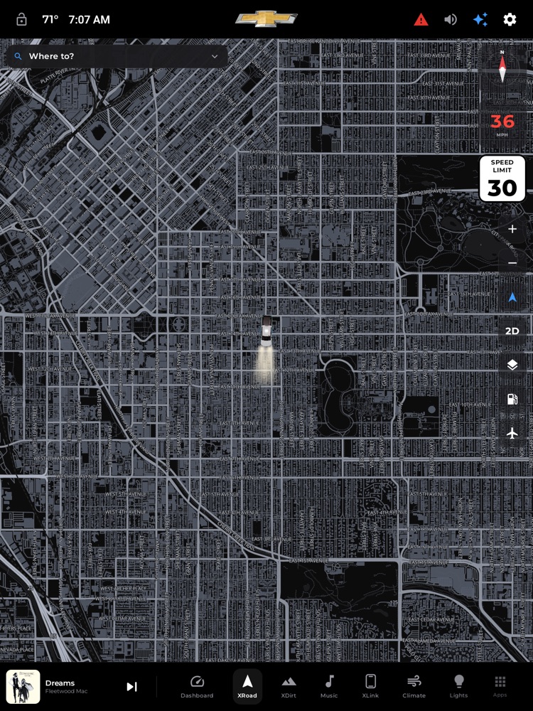
XRoad on-road navigation: the 3D street map, the truck marker, search, and the control rail.
XRoad is your everyday street navigator: a big, clean map with your truck on it, turn-by-turn directions read out loud, and a live speed-limit sign so you always know the posted limit at a glance. It's built for a truck, so it can also warn you about low bridges and weight limits when you're towing, and it'll help you find fuel without ending your trip.
Where to find it: Bottom dock › XRoad tab (the navigation-arrow icon). It also opens automatically the moment a route starts — for example, when you pick a station from the Critical Fuel prompt.
When you'll use it: Getting to an address, running errands with a couple of stops, pulling up the map to check where you are and how fast the road is, or navigating with a trailer hitched up and needing rig-safe directions.
The screen, part by part
The map and your truck
- A full-screen map fills the tab. Your truck rides as a smooth 3D marker that glides along and turns to face your direction of travel — no jumpy dot.
- Right edge — map controls (always there, planning or guiding):
- + / – zoom the map in and out.
- Orientation chevron cycles how the map is oriented: free-roam (a plain black arrow — pan the map anywhere and it won't recenter), north-up (a blue arrow — centered on you with north at the top), and heading-up (a blue arrow with a little forward cone — the map spins so your direction of travel is always "up").
- 2D / 3D flips between a flat top-down map and a tilted, three-dimensional view with buildings.
- Layers switches between the standard map and a satellite view.
- Fuel pump turns gas-station pins on and off.
- Airplane turns the nearby-aircraft overlay on and off.
- Top-right instrument stack (all the same size, easy to read):
- Compass — a red north needle. It rotates with you in heading-up mode and sits upright otherwise. Tap it to snap straight to north-up.
- Speedometer — your current speed in big numbers with "MPH" beneath. The number turns red when you're over the posted limit.
- Speed-limit sign — a white US-style "SPEED LIMIT" sign with the posted number, shown whenever a limit is known for the road you're on.
Planning a trip (before you start driving)
- "Where to?" bar at the top-left. It starts as a single slim line so the map stays open. Tap it (or its chevron) to expand the planner downward; tap again to collapse it. Once you've set a destination, this bar shows its name.
- Trip editor (when expanded):
- Your location — the starting point, always your live GPS position.
- A big "Where to?" field for your destination. Tap it and type; a clear ✕ wipes what you've typed.
- Add stop — appears once you have a destination, to string together multiple stops in order. Each stop has its own ✕ to remove it.
- Quick destinations (shown before you start typing): Home and Work tiles (tap to set them the first time, tap to go after that), plus a Recent list of places you've navigated to.
- Search results appear as big tappable rows as you type, each with an address and the straight-line distance so two same-named places are easy to tell apart.
- Route choices — once a destination is set, XRoad offers a few routes to compare. Each shows travel time, arrival clock time, and distance, with Fastest and Shortest badges. Tap one to select it (a bold outline and a check mark show your pick). Below the choices are Cancel and a big Start button.
While you're driving (guidance)
- Next-turn banner across the top: a large turn arrow, the distance to the turn (feet up close, miles when far), and the instruction. On highways this becomes a green exit sign with the ramp number and destinations.
- Lane guidance — as you near a turn or exit, a row of lane arrows appears, highlighting the lane(s) you should be in.
- Bottom bar — three equal cards for Time, Distance, and Arrival clock time, plus a red End button to stop navigating.
- Top-left buttons:
- Mute (speaker icon) — silences or restores the spoken directions. It turns red when muted.
- Add a stop (+) — opens a panel to search, pick nearby gas, or choose Home/Work/a recent place, then reroutes you through it without ending guidance.
How to navigate somewhere
- Open the XRoad tab and tap the "Where to?" bar to expand the planner.
- Tap the destination field and type an address or place name, then tap a result. (Or tap Home, Work, or a recent place to skip typing.)
- Review the route choices — check the time and distance, and tap the one you want.
- Tap Start. The map zooms in behind your truck and directions begin.
How to add extra stops
- Before you leave: after setting your destination, tap Add stop in the trip editor and pick a place. Stops are visited in order; drag isn't needed — just remove and re-add with the ✕ if you want to reorder. XRoad recalculates the route through every stop.
- Mid-trip: tap the + (Add a stop) button top-left, then search or tap a nearby gas station, Home, Work, or a recent place. XRoad reroutes you through that stop and keeps guiding — no need to restart.
How to mute or unmute spoken directions
- Tap the speaker button at the top-left while guiding. Muted shows a crossed-out speaker in red; tap again to bring the voice back.
How to recenter and follow the road
- If you've panned the map away, tap the compass (snaps to north-up) or tap the orientation chevron until it turns blue to recenter and follow you again. While actively navigating, the map already follows your truck automatically with the road ahead filling the screen.
How to detour to a gas station
- Tap any green fuel pin on the map (turn on the fuel-pump control first if you don't see them). A card pops up with the station's name and brand.
- While driving, the card prices the detour first ("Adds 4 min · 1.2 mi") so you commit with eyes open. Tap Add stop to reroute through it. A brief Undo bar then appears — tap it to snap back to your original route.
- While planning, tapping Add stop simply adds the station to your trip.
How the "Critical Fuel" rescue works
- If your fuel drops to a critical level and you're not already navigating, xOverland takes over the whole screen with a Critical Fuel prompt listing the nearest stations by distance. Tap one and it builds a route and drops you into XRoad guidance. Tap Not now to dismiss it. It only fires once per low-fuel episode (it won't nag), and re-arms after you refuel.
What you need
- GPS / location: XRoad needs a location fix to place your truck, search near you, and guide you. Search, maps, and live traffic-free routing all use a data connection.
- Live speed limits & gas pins come from free open map data over the internet — no account or key required. When you're offline, gas pins and aircraft simply won't load, and a posted limit shows only when one is known for your road.
- Rig-safe routing (low-clearance and weight warnings) only kicks in when a trailer profile is active — set one up under Settings and hitch it in. With no trailer, XRoad routes your truck normally and doesn't run the rig scan (a bare truck clears almost everything).
- Critical Fuel rescue needs a supported OBD-II adapter paired so xOverland can read your actual fuel level, and the "Route to gas when critical" alert switched on in Settings. Without a fuel reading, the automatic prompt won't fire — but you can still tap gas pins on the map anytime.
Tips & good to know
- Typing is blocked while moving — on purpose. Once you're rolling above a walking pace, the destination field locks and shows "Tap to type — passenger only." Tapping it raises a Passenger only notice; it's meant for a passenger to enter the address, and unlocks typing for the rest of that trip once accepted. If you're the driver, use Scout — the sparkle (✨) — in the header to ask for a destination hands-free, or tap a saved Home / Work / Recent place — those stay tappable at all times.
- Rig hazard warnings while towing: if your route crosses a low bridge or a weight-limited span for your truck-plus-trailer, XRoad flags it before you start (with the posted limit vs. your rig) and keeps a warning banner up as you approach, and speaks a heads-up once when you're near — so a plan-time warning isn't the only chance you get. These come from posted map data and are advisory, not exhaustive: pick a route without warnings, or verify the clearance yourself. If the check can't run or a route is too long to scan fully, XRoad says so plainly rather than pretending it's clear.
- Route choices are about trade-offs, not just the fastest line — you can pick the shorter route, or the one that avoids a rig hazard.
- Off-route? It reroutes itself. If you miss a turn, XRoad quietly builds a fresh route from where you are and keeps going.
- Nearby aircraft is a fun ambient extra: with the airplane control on, live planes overhead appear as little glyphs on the map. It's for curiosity, never a driving input, and it just won't show when you're offline.
- Gas price context: with gas pins on, a small chip in the corner shows the regional and national average price for regular so you know if a stop is a good deal.
- The map follows your day/night theme, and the whole layout uses big, glanceable controls so you can work it at a glance while the truck is stopped.